43: Postcards From the Edge
A simplified map of the Itsaq Complex, modified from Nutman et al., 1993. The island of Akilia from Eps. 40-42 is in the lowermost red zone. The area of Isua is in the uppermost blue zone.
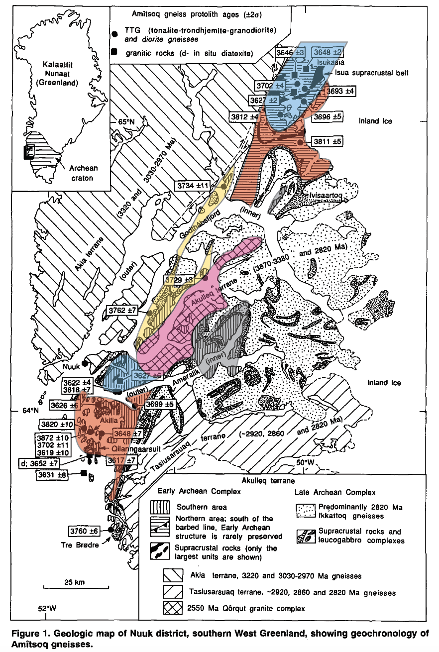
Since Episode 36, we’ve been investigating the oldest rocks in Greenland. These ancient stones are 3.9 to 3.6 billion years old. On our imaginary Earth Calendar, that’s Feb 23 – March 19. They’re not Earth’s oldest rocks, but geologists consider them the first major glimpse onto our planet’s early days for two reasons. 1: The Greenland rocks are more well-preserved than older spots, and 2: they cover a much larger area: 3,000 km2, larger than Rhode Island, larger than Luxembourg.
This area is called the Itsaq Complex. The best way to think about Itsaq is to imagine a thin vertical banner hanging on the wall, a patchwork quilt of stone stretching from the ceiling to the floor. Most of the patches are made from dull gray tonalite, a cousin of granite that tells us how islands became continents. Scattered throughout this gray tonalite tapestry are much smaller splashes of color: black, red, and green. These areas are windows onto the ancient seafloor, preserving dark lava flows, rusty iron, and maybe evidence for life.
For the past three episodes, we’ve studied just one of these technicolor windows, a small corner of a small island named Akilia at the very bottom of the banner. After much deliberation, most scientists think this island is one of the oldest patches of the great Greenland tapestry. Akilia is Earth’s oldest surviving slice of seafloor (that we know of), with lava and iron erupting deep beneath the ancient waves. Life was almost certainly around, but the evidence remains inconclusive.
Our next destination is the opposite of Akilia in many ways. While Akilia sits at the bottom of the great Greenland banner, floating in the ocean, our new destination is at the banner’s top border, far to the north, on the edge of titanic ice sheets. In terms of size, the Akilia rocks from the past three episodes could all fit inside a large sports stadium, a quick five-minute jaunt. Today’s location is much wider, spread across 35 kilometers, 22 miles. It also has the most pristine rocks we’ve yet seen, the greenest pastures for finding fossils. In other words, these rocks are bigger and better than anything we’ve seen so far. This is the final destination of Season 2.
Today, I’ll give an overview of this new Greenland location: a roadmap so we can divide and conquer in future episodes. The youngest rocks in this area will bring us right to the season’s end. I truly have saved the best for last- let’s dive in.
Part 1: The Age Lab
It’s summer, 1971. A helicopter flies north over the great Greenland landscape, over snow-capped mountains plunging into blue fjords. There are no roads out here, only natural highways of sea and air. In front of the helicopter, the northern horizon is swallowed by a solid wall of glacial ice, slowly getting closer, larger and more detailed.
Two men sit inside the copter, looking down at the landscape below. It’s hard to talk over the propellor’s roar, but they can still point out interesting layers and peaks to each other. They’re on their way to examine an iron mine on the edge of Greenland’s ice sheet. The younger man is taller, clean-shaven, and a very familiar face to us. This is Vic McGregor, the New Zealand geologist who opened Greenland’s oldest rocks to the world. He’s been our constant companion since Episode 36 and by 1971, he’s already spent years exploring the Greenland wilderness.
Sitting across from Vic is a shorter, balding man with a dark goatee. His name is Stephen Moorbath, and he’s flown all the way from Oxford, England to visit Vic and his rocks. We briefly met Moorbath in Episode 37, but he deserves a more proper introduction here.

Stephen Moorbath, admiring a 3.8 billion year old gneiss from Greenland. (Credit: The Royal Society)
Moorbath was born in 1929 in Magdeburg, Germany. His original name was Stefan Irwin Mosebach. The Mosebach family was Jewish, but young Stefan attended a Catholic convent for education, when the Nazis forbade Jews to attend public schools. The nuns protected Stefan when his father Heinz was taken away to Buchenwald, one of the Nazis’ largest concentration camps. Miraculously, Heinz bribed his way out of the camp, likely due to a shiny Military Cross awarded as a World War I veteran. Young Stefan and Heinz were able to secure passage to the United Kingdom, but his mother Else was not as fortunate. The war made it impossible for her to cross the sea. She wrote letters to her family, but eventually perished in Theresienstadt Ghetto in 1942, alongside 33,000 other souls.
After all this hardship, Stefan was only 13 years old. In the UK, he now had the extra hardship of being a German living in a country at war with his homeland. His father Heinz was briefly held in a British internment camp, despite no wrongdoing. Stefan (now Stephen) was sent to a family in Oxford, England. Burying himself in schoolwork, he found a love and talent for chemistry, but hit a new roadblock: money. He needed funds to finish high school, so he worked as a lab technician for Oxford’s biochemistry department. This was not your everyday lab: Stephen was working for the folks who developed penicillin, many of whom would receive knighthoods and Nobel Prizes.
Stephen was inspired, but still needed to finish schooling. Once a week, Stephen was allowed to attend evening classes, chipping away for three years until he finally got his high school degree at 19. If you’re a student with a job or three on the side, you’re not alone out there. Fortunately, Stephen’s story improves from here. Oxford University became his permanent home, first as a student eating cheap Indian food and joining ghost-hunting clubs, then as a distinguished professor in 1956.
His broad interest in chemistry focused into geochronology: the study of dating rocks. Not taking them out for a nice dinner, but figuring out their ages. It was researchers like Moorbath who helped nail down a solid timeline of Earth’s ancient past. If you want to learn more about that subject, check out Episode 3: The Dating Game. The one-sentence summary is that uranium decays to lead at a known rate, just like the ticking of a clock. Moorbath became an expert in reading these clocks, their hiccups and quirks. He called his new laboratory “The Age Lab”, and began to date rocks around Scotland. Some were among the oldest known at the time, 2.7 billion years old, May on the Earth Calendar. Moorbath was beginning to reach back into the truly ancient past, and his skill was getting noticed around the world, including Greenland.
In Episode 36, we met Vic McGregor roaming around Greenland’s capital of Nuuk, unraveling a Gordian knot of old rocks. He hypothesized that the stones were old, but needed proof. In Episode 37, he sent his rocks to Moorbath’s Age Lab in Oxford. Moorbath was happy to measure their ages, but didn’t think they would amount to much. He promised his grad student Lance Black a bottle of wine for every sample older than 3 billion years. That’s how confident he was that the Greenland rocks were young. When all was said and done, Moorbath owed 8 bottles of wine to his student, but it was a happy donation. McGregor was right- these were the oldest rocks on Earth (at the time).
This was the beginning of a powerful relationship. Vic McGregor knew the ancient Greenland landscape like the back of his hand. Stephen Moorbath could figure out how old those rocks were. A few months after Moorbath measured McGregor’s samples, the two men finally met in person to explore a new Greenland location, which brings us back to the chopper. Moorbath had been through hell, but now he was heading to the top of the world.
Part 2: The Ice Limit
Greenland has no highways. The world’s largest island, the size of Mexico or Saudi Arabia, has only 150 km (90 mi) of road, and less than half are paved. For reference, the smallest US state of Rhode Island has 21,000 km or 13,000 miles of road. It’s a remote land here.
Most of Greenland’s roads are found in and around the coastal capital of Nuuk, but they don’t connect you to anywhere else. To reach nearby settlements and islands, you must take a boat or if you’re really intrepid, take a hike. That’s exactly how Vic McGregor started his mapping- hiking and boating around the Nuuk capital. The town had under 10,000 folks at the time, but was still a welcome sight to return to after a few days in the field.
Vic’s first batch of rocks, the ones he sent to Stephen Moorbath, were clustered around the Nuuk shoreline, but he knew there was so much more to discover. Using our banner analogy: Vic was studying the frayed bottom of the banner, but wanted to journey farther up, farther north. In 1971, he got a lucky break.

The Isukasia region, now known as “Isua”. The iron mine visited by McGregor & Moorbath is between the glaciers in the distance. (From Eurekalert)
The only folks with the money and infrastructure to place roots in Greenland’s harsh interior were mining companies. A few ventures had found a large deposit of iron ore 100 km NE of Nuuk, on the edge of the Greenland Ice Sheet, the top of our imaginary banner. They knew about Vic’s expertise and his recent success with Stephen Moorbath. They were willing to fly these two geologists to their iron mine to see what they had.
When I say this mine was at the glaciers’ edge, I mean nearly swallowed by the glaciers. Imagine standing on top of a mountain. In one direction, you see a land of rolling tundra hills and large silty lakes. Turn in the other direction, and you’ll see a flat plain of ice extending to the horizon and tumbling down the mountainside like titanic frozen waterfalls.
This area is called Isua, that’s I-S-U-A, Isua. At least, that’s what it’s called now. There were some mislabeled maps, some miscommunications, the real Isua is a few miles away… even for a name nerd like me, it’s too much. The name Isua has stuck in the scientific lingo, and we’re going to use it here. Accidental or not, it’s a fitting name. In Greenlandic, Isu means “the edge”, just like the edge of the glaciers.
McGregor and Moorbath touched down in their helicopter and set to work. Immediately, Vic was excited. The rocks here looked extremely similar to his first forays around Greenland’s, with one major exception: they were in much better condition. To paraphrase a letter to a colleague: “It would not surprise me at all if at least some of these Isua rocks prove to be equivalent to the Nuuk area”.
One rock in particular stood out, one you might have already guessed based on context clues. The reason McGregor and Moorbath were visiting Isua was thanks to an iron mine. Say it with me now, this rock was… a banded iron formation or BIF. We’ve seen plenty of BIFs before, they were once dark seafloors where iron rained down from waters above. We saw BIFs in Canada (Episode 32) and elsewhere in Greenland (Episode 41), but they were too small to place mines on. The fact that industry was willing to dig for iron in Isua, a hundred miles from the coast, next to giant glaciers, with no roads in or out, should hopefully tell you we’re in the big leagues now.
But the BIF was just the beginning. As they looked, they saw other types of rocks, common today, but ones we have not yet seen on the show: rocks like sandstones and limestones. The two geologists collected their rocks, thanked the mine, and headed home. Back in Oxford, it was Moorbath’s turn to shine. He measured the ages of his newly-collected Isua rocks and found that McGregor was right. The Isua samples were 3.7 billion years old, March 11 on the Earth Calendar, around the same age as Vic’s first samples from the capital.
I can’t stress how huge this discovery was. McGregor and Moorbath’s team had already described the oldest rocks in the world around Greenland’s capital. Now they had found rocks of similar age 100 km away, indicating a huge area of very ancient stone. Even better, these Isua rocks were in much better shape and preserved evidence for ancient sediments and seafloors. If there was anywhere to find Earth’s oldest fossils, or Earth’s oldest anything, it was here, on the edge of the ice.
Just two years later, the mining company decided the distance and logistics were too much, and closed down their operations in Isua. But they had opened a fresh mine of information, one that scientists are still visiting today. If industry would not fund future expeditions, it was now up to research grants to pave the way. The race was on.
Part 3: Return of the SHRIMP
International teams of geologists have explored the Isua region for over 50 years, creating increasingly accurate maps from field sketches to digital atlases. For this last segment, we’re going to make our own mental map of Isua, to get a lay of the land for future episodes. If you want to see real maps, check out our website: bedrockpodcast.com. There’s a link in the description.
I want you to imagine the letter U made of stone. OK, have that burned in your brain? Now imagine that this U is stamped onto the Greenland tundra. Each side of the U (left, right, and bottom) is roughly 12 kilometers or 7 miles long, around a quarter marathon to run.

The first map of the Isua region by Keto & Kurki 1967, modified by Nutman et al., 2019. The U-shape is what we’re interested in.
Let’s start where we left off: the old iron mine that McGregor and Moorbath examined. This mine sits in the upper right corner of that U, the end of the road. As we travel down this right arm, we’re walking along the glaciers’ edge: ice to the east, rocks to the west. Here, we will see rocks that formed in the ocean’s shallow end, much closer to the beach. Until now, we’ve only seen the deep, dark seafloor- it will be good to see a new habitat. We will also witness a fresh debate about potential fossils- not microscopic flecks of carbon, but weird lumps you can see with your own two eyes.
As we curve down into the bottom of the U, we pull away from the ice and onto the open tundra. Here, we must cross a huge lake, over a mile wide, to reach the other side of the U. The ancient rocks are still there, just hidden deep under lake water. When we land on the other side, we begin up the left arm of the U. The rocks here are spread out much wider, giving us plenty of space to explore. On this left side, we will return to a question I left open-ended in Episode 39: how were the first continents built? We will also see even more fossil debates for you paleo nerds out there.
Let’s zoom back out to our birds-eye view of Isua, that giant U-shape spread across the Greenland landscape. We begin with our usual question: How old are these rocks?
To answer that question, let’s return to Stephen Moorbath’s lab in Oxford. The first dates measured from Isua were around 3.8 billion years old, March 3 on the Earth Calendar. However, as important as these dates were, there was a slight issue. On this show, I give you broad dates like 3.8 billion, or 3.76 billion if I want to be ultra-precise. However, there’s always some imprecision when dating a rock, some wiggle room for error. Scientific journals make these imprecisions very clear. For example, Moorbath reported his date as 3.76 billion, give or take 70 million years.
You might be saying, “Whoa, give or take 70 million? That doesn’t seem very precise.” Some of you might even be saying: “Aha! I knew this whole age-dating business was a scam, the Earth can’t possibly be billions of years old!” Or perhaps you’re perfectly fine with these numbers. In any case, let me put my straw-men aside and work through these digits.
An error range of 70 million years is a long time, but consider the main age: 3.76 billion. Without turning this into a number soup, the error bar here is a measly 2%. Imagine you pick up a bucket of candy that says “Around 100 pieces inside”. Maybe it’s 98, maybe it’s 102. In either case, you’re basically getting what you pay for. That’s the margin of error in Moorbath’s original paper. For 1972, the simple fact that it was over 3 billion years old was good enough.
As more research was done, the age estimates only grew more precise. By the eighties, the error bars had been shaved down to just two million years. Again, two million years is an unfathomable amount of time for humans to imagine. But considering these ancient Greenland rocks, that’s less than a 0.05% error. In our candy analog, that’s just an extra grain of sugar in the bag. Part of this innovation is thanks to a man and a machine we met way back in Episode 10, and briefly again in Episode 25. The man is Bill Compston at the Australian National University in Canberra. The machine is called the sensitive high resolution ion microprobe, but we know it better as the SHRIMP.
In short, the SHRIMP can get an age date from just a fraction of a crystal, instead of grinding down a whole rock. Far more dates could be gleaned from far less material. Bill Compston and his SHRIMP gave us dates for the oldest material on Earth in Episode 10, and the oldest rocks on Earth in Episode 25. Compston also did the first SHRIMP analyses of Isua in the 1980s, but he won’t play a major role in future Greenland episodes. It’s just nice to see an old face return, even if briefly.

Allen Nutman
Instead, another researcher would take the wheel, a man we’ve spent a lot more time with recently: Allen Nutman. Nutman was the first major player we met on Akilia Island, Episodes 40-42. He will also play a major role in the Isua story, so it’s fitting that we start with him again. In 1996, Nutman and his team published a landmark paper, gathering rock ages from around SW Greenland. This was the very same paper that started all those Akilia debates way back in Episode 40. As a reminder, the Nutman crew said Akilia island was nearly 3.9 billion years old, February 25th on the Calendar.
So what about Isua, our new stomping grounds? These rocks are younger than Akilia Island. We’re moving the story forward from February 25th to March 3rd on the Calendar, a solid 3.8 billion years ago. We’re finally in a new month! But wait, there’s more.
Team Nutman realized there was a pattern to the ages in Isua, which brings us back to our mental map. When you’re ready, imagine that giant U of stone spread across the tundra. Got it? Good. Here’s what Team Nutman found. Everything below the U was older: March 3rd, 3.8 billion years old. All the rocks above the U, cradled like soup in a bowl, was younger: March 11th, 3.7 billion years old. Here’s an even simpler analogy. Imagine a smile made of stone. The lower lip is older rock, the upper lip is younger, and the teeth in between are, well, in between.
As with everything in Greenland, this idea was debated. According to Nutman, one reviewer called his paper “a stream of geo-diarrhoea”, which is unnecessarily harsh and just plain gross. But as more rocks are dated, this idea has become more accepted. For the next few episodes, we will use this timeline to explore the ancient rocks of Isua. Physically, we will move from south to north, crossing this giant U of stone. In time, we will amble forward from 3.8 to 3.7 billion years ago, a week of the Earth Calendar. We will see the birth of islands, volcanic eruptions, completely new types of rock, and even more features that may or may not be fossils. Welcome to Isua, our best and biggest playground yet!
Summary:
In the world of ancient geology, the name Isua is often mentioned with a level of respect, or even awe. It is an incredibly tough place to reach, 100 km north of Greenland’s capital with no roads in between. The massive Greenland ice sheet perpetually looms on the horizon, a relatively new feature guarding much, much older rocks below. These rocks are the most extensive and well-preserved for their age. Over 50 years of research, they have changed how we think about the early Earth: its’ continents, oceans, and life.
This episode is just the appetizer. Over the next few weeks, we will dig into a buffet of stories. We’ll start with the oldest rocks in the region’s south, 3.8 billion years old. Then we’ll work our way forward in time to the youngest rocks in the north, 3.7 billion. This early week of the Earth Calendar, March 3-11, gives us a real glimpse of what’s to come, and will conclude Season 2. I’m incredibly excited to tell you all about it. Let’s go.